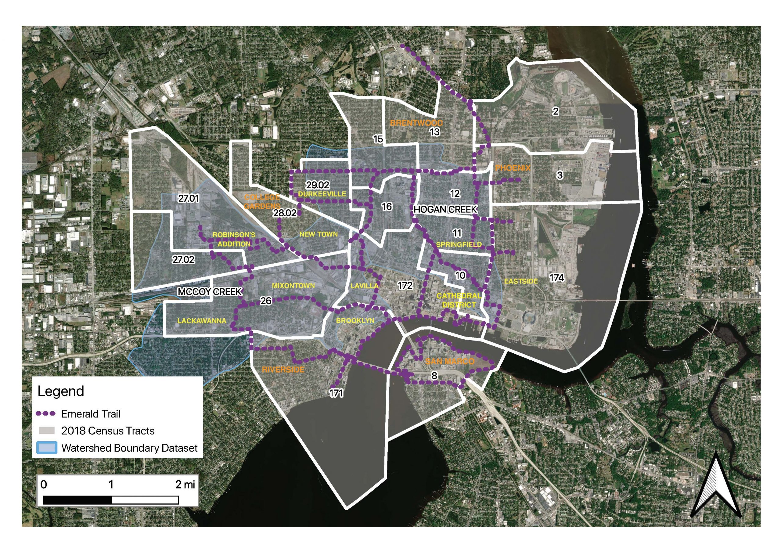
Groundwork Jacksonville is leading the effort to create an ecologically-based watershed restoration and management plan for two watersheds within Jacksonville’s urban core – McCoys Creek Watershed and Hogans Creek Watershed. For the project, Groundwork will be collaborating with 10 urban neighborhoods, the City of Jacksonville and other key partners.
The project is funded through a $718,809 grant from the Florida Department of Economic Opportunity’s (DEO) Rebuild Florida General Planning Support Program. Groundwork hopes the plan will be a model the City of Jacksonville can replicate throughout other regional watersheds.
A watershed is the area of land where water drains to a common location, such as a creek, river or stream. Watershed planning is a holistic approach to addressing water resource and quality issues that involves multiple stakeholders in the process, and provides a forum for community discussion and input into the strategies that will be implemented.
Groundwork’s goal for the Watershed Plan is to identify specific remedies to reduce flooding, improve water quality, increase community resilience, restore habitat, and improve access to recreation.
Another outcome will be increased community knowledge about resilience and healthy watersheds, and the creation of community stewards and partners who will work with GWJax to install green infrastructure throughout their communities.
McCoys Creek Watershed
The McCoys watershed is 5.75 square miles and includes McCoys Creek, a 2.8-mile tidal and freshwater creek. McCoys Creek is the City’s #1 priority in the Local Mitigation Strategy, identifying the creek as high risk for flooding, storm surge and sea level rise.
Within the McCoys Creek Watershed, the City’s Master Storm Water Management Plan (MSMP) identifies 26 local roads that currently flood during a five-year storm event and do not meet Level of Service (LOS) standards. Approximately 542 structures are at risk of flooding within the watershed and dozens flood more than once per year.
Hogans Creek Watershed
Hogans watershed is approximately 3.2 square miles and includes Hogans Creek, a 2.6-mile tidal and freshwater creek.
Hogans Creek is listed as the #2 priority in the City’s Local Mitigation Strategy, identifying the creek as high risk for flooding and storm surge. Like McCoys Creek, it was straightened and bulkhead in the 1920s. The entire creek is fully unnatural and separated from its floodplain, leading to increased pollution.
Area of Impact
The Watershed Plan will benefit 10 distinct neighborhoods within 14 census tracts of the urban core. Sixty-eight percent of residents in the neighborhoods are African-American. All census tracts in the geographic area have populations where 50% or more of the population is considered low, very low, or extremely low income. Nine of 14 census tracts have populations where 75% or more of the population is considered low, very low, or extremely low income.
HUD’s 2020 adjusted income limits for a household with two people:
• Extremely low income (less than $18,000)
• Very low income ($18,000 – $30,000)
• Low income ($30,000 to $48,000)
Engaging residents within these 10 impacted neighborhoods will be key to understanding what residents consider the most important assets of and the biggest threats to the watershed. In addition, Groundwork and its partners will evaluate each neighborhood’s capacity and willingness to participate in long-term implementation strategies.